
Urgent! Cyclone brings torrential rain, strong winds and widespread power cuts! Auckland grinds to a halt, with worse danger still ahead…
The National Emergency Management Agency says Cyclone Gabrielle will affect much of the North Island, with strong winds, heavy rain and huge waves forecast from Monday to Tuesday

New Zealand’s North Island has been hit by Cyclone Gabrielle before fully recovering from the last bout of flooding and torrential rain.
The National Emergency Management Agency says Cyclone Gabrielle will affect much of the North Island, with strong winds, heavy rain and huge waves forecast from Monday to Tuesday. The agency expects this to be an unprecedented and dangerous weather event.

New Zealand’s MetService has issued its highest-level red warnings for heavy rain and strong winds in Auckland, lasting from 10h on Monday to 3h on Tuesday.
As the cyclone wreaks havoc across the North Island, Auckland has largely ground to a halt。
Almost all Auckland schools have chosen to close, all train services have been cancelled, buses may be delayed, and ferries may also be cancelled depending on conditions. Air New Zealand has cancelled all domestic flights to and from Auckland, Hamilton, Tauranga and Taupō before midday Tuesday. On the North Shore,
the Harbour Bridge could close at any time. Auckland’s libraries, community centres, early childhood centres and activity centres have all closed, and Monday and Tuesday rubbish collections have also been postponed.
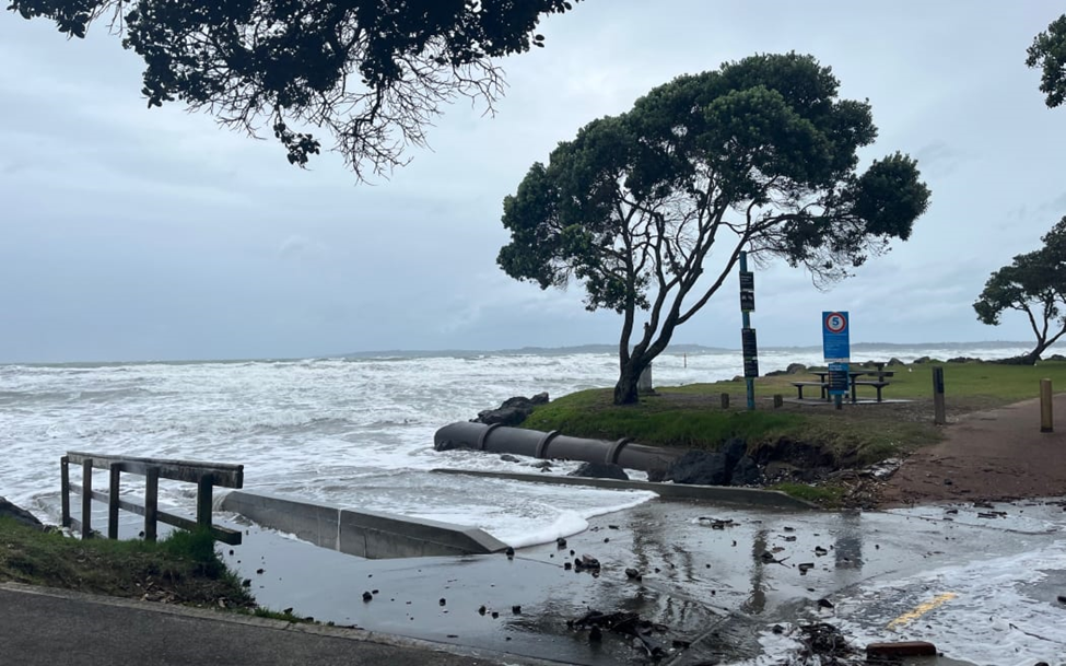
Strong winds and a rising tide at a beach in northern Auckland. Photo: Rhonwyn Newson
The cyclone has also caused widespread power cuts. By Monday morning, around 50,000 households across Northland, Auckland and Coromandel were without electricity. Counties Energy told customers to prepare for prolonged outages over the coming days:
“Some properties could be without power for days if the damage is severe.”
Fire and Emergency said: “The number of households without power will keep changing as we respond to emergencies, but with the weather deteriorating, we expect further outages tonight and tomorrow.”
It said it had received more than 180 weather-related calls in the 12 hours to 5h on Monday, involving loose roofs, fallen trees, damaged windows and downed power lines. Fortunately, no casualties have been reported so far.
{ad}
Peak wind speeds have reached 140 kilometres per hour, equivalent to force 13 on China’s wind scale, and are expected to generate waves and coastal flooding. Waves 11 metres high have already been recorded in the Bay of Islands.
Winds of this strength could also bring down trees and power poles across wide areas and damage roofs. Pedestrians and drivers could encounter building debris and tree fragments blown into their path at any time, potentially putting their lives at risk. Already, some homes in
Northland have had their roofs completely torn off. MetService advises everyone to stay indoors as much as possible and avoid unnecessary travel.
But the most dangerous conditions may still be ahead!
MetService warns that the worst may be yet to come as the cyclone moves towards New Zealand. Even more extreme wind speeds are possible later on Monday.
In Auckland, rainfall and wind speeds began building to alarming levels from midday Monday.

MetService forecasts a further 120 to 200 millimetres of rain on top of what has already fallen, creating dangerous river conditions and severe flooding. Winds could peak at 120 to 130 kilometres per hour in exposed areas, causing
severe damage to trees and power poles and potentially tearing off roofs. Flying debris and falling trees could threaten lives.
How can we protect ourselves and our families as the cyclone strikes? Have you secured the trampoline in your garden and the plants on your balcony, and made arrangements for your pets? YIJU New Zealand has put together these practical tips. Take a look:
What should you do if the power goes out at home? Keep these points in mind:
- Have torches, batteries, a camping stove or a barbecue ready.
- Take care when using candles to prevent fires.
- Use heating safely. Do not use outdoor gas heaters indoors.
- Listen to the radio for updates. You can listen in your car or on your phone, although it is best to conserve your phone’s battery.
- You can go to a community centre to charge your phone and have a hot drink.
- Food in fridges and freezers needs to be dealt with or discarded to avoid food poisoning.
- Many insurers cover food spoilage caused by power cuts and may also cover temporary accommodation if you cannot stay at home. Contact your insurer to ask.
YIJU’s editorial team reminds everyone to avoid going out unless necessary! If you must leave home to seek shelter, emergency shelters have been open in Auckland since Sunday evening.
- List of Auckland civil defence centres and shelters:
www.aucklandemergencymanagement.org.nz/flood-event-2023/civil-defence-centres-community-hubs-and-shelter-sites#CDClist
- Auckland emergency flood reporting and assistance hotline, which can also provide information about nearby civil defence centres:
0800 22 22 00
- Auckland flood and stormwater reporting hotline:
09 301 0101
- Information about New Zealand flood assistance payments, which are also available to non-residents who meet the eligibility criteria:
www.workandincome.govt.nz/products/a-z-benefits/civil-defence-payment.html
- Check Auckland power outages:
Vector:help.vector.co.nz/mapCounties
Energy:app.countiespower.com
- Information about Auckland public transport cancellations and delays:
at.govt.nz/about-us/news-events/service-disruptions/severe-weather-impact-across-the-auckland-area/
If life or property is at immediate risk, call 111 for emergency assistance!
Please take care as the cyclone strikes. Save this essential information and share it with the people you care about!