
Auckland revises its long-term property plans: homeowners celebrate as landholders worry
Auckland is revising its long-term property plans, with implications for many people's wealth. Homeowners stand to gain significantly, while major infrastructure and development companies face substantial losses.
Auckland is revising its long-term property plans, with implications for many people's wealth. Homeowners stand to gain significantly, while major infrastructure and development companies face substantial losses.
The draft FDS and its implications for people's wealth
Auckland Council released a new draft Future Development Strategy, or draft FDS, in early June.
The council's proposed changes could significantly influence future property investment decisions and outcomes. Whatever the consultation produces, the broad direction, grounded in current realities, is unlikely to change. Put simply:
The city's outward expansion will slow or even stop. The council has little money or capacity left to build infrastructure, so it must accommodate future population growth by increasing density around existing facilities.
The draft FDS is currently open for consultation, with the final deadline extended to the end of July. The final FDS will replace parts of the Auckland Plan 2050, the 2018 Development Strategy and the 2017 Future Urban Land Supply Strategy, affecting many people's wealth.
The FDS has been prompted by New Zealand's National Policy Statement on Urban Development 2020 (NPS-UD) and environmental legislation covering matters such as climate change, which require revisions to existing urban development plans. The FDS will be updated every 5 years to respond to future development.
FDS: key provisions and implications
So what exactly does the FDS contain? In essence, it has 4 main points and 2 maps:
The 4 main points are:
01
Most of Auckland's future growth should take place in locations that suit most people: close to the city centre and easily accessible by public transport.
02
Greenfield land—undeveloped land on the urban fringe—will be a secondary priority. Development will wait until infrastructure such as transport networks is more fully established, meaning it will begin later in a programme spanning 30 years. Development of some greenfield areas will be abandoned because of inefficient transport, excessive carbon emissions and construction risks.
03
Limited funding must be concentrated on transport and water infrastructure, taking factors such as investment returns into account and prioritising areas where more people will benefit.
03
In the first 10 years, development will focus on Mt Roskill, Tamaki, Māngere, Auckland's city centre, Westgate and parts of Drury-Ōpaheke. Some selected alternative areas will become the main focus of the second phase.
The 2 maps are also very important. One covers 10 years and identifies priority and secondary-priority areas for property development. The other covers 20 years and sets the direction for future infrastructure investment, including transport.
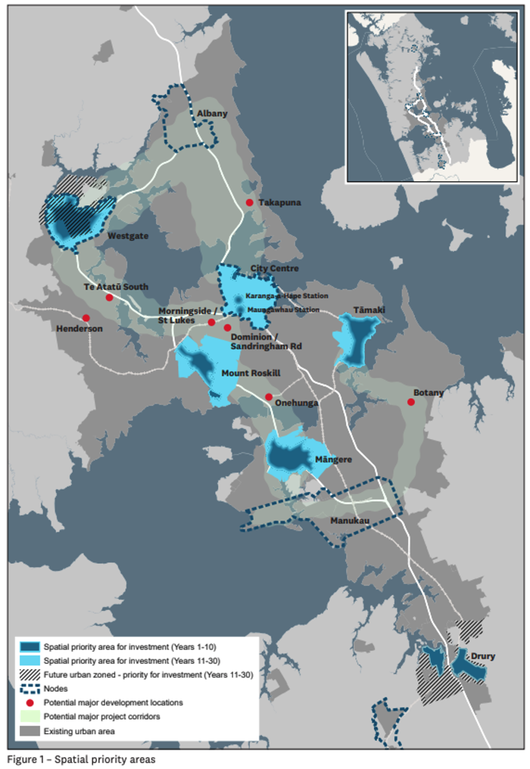
The map below shows priority and secondary-priority development areas. Alongside the confirmed priority areas listed, red dots mark secondary-priority areas.
Serviced land and established urban areas set for price rises
Limited infrastructure capacity means existing assets, such as railways and motorway networks, must be used more intensively. Land with convenient transport access will therefore become more valuable.
The plan clearly emphasises existing railway lines, as illustrated by the sections labelled “Focus development around stations” and “Invest in quality infrastructure” in the map below. In essence, Auckland has decided to move away from cars and fully embrace public transport.
By reducing expectations of future greenfield land supply, the draft FDS makes it difficult for major developers to build large new communities on the urban fringe using their own resources alone. This will put upward pressure on land prices in established areas, benefiting all current homeowners.
The dark blue areas in the map above will be developed at high density. Alongside a green light for housing construction, investment in education and commercial facilities will follow.
To connect development between these areas, known as urban subcentres or nodes and shown by blue dashed lines in the map above, the council has provided 4 development scenarios. These are broadly similar, essentially increasing density along existing infrastructure.
For outlying areas, the FDS identifies Warkworth and Pukekohe as important agricultural hubs where infrastructure investment will continue. Other suburban areas will have to wait for a future that may arrive at some unknown point.
Some major companies stand to lose
Limited resources will be directed towards these important nodes, making it difficult for large areas of the urban fringe outside them to receive meaningful infrastructure investment in future.
Even in the relatively distant second phase, more than 10 years away, new residential areas will be concentrated in northern locations such as Kumeu-Huapai-Riverhead and Silverdale West-Dairy Flat, Wainui, Upper Orewa. These are shown on the second important map in the FDS document.
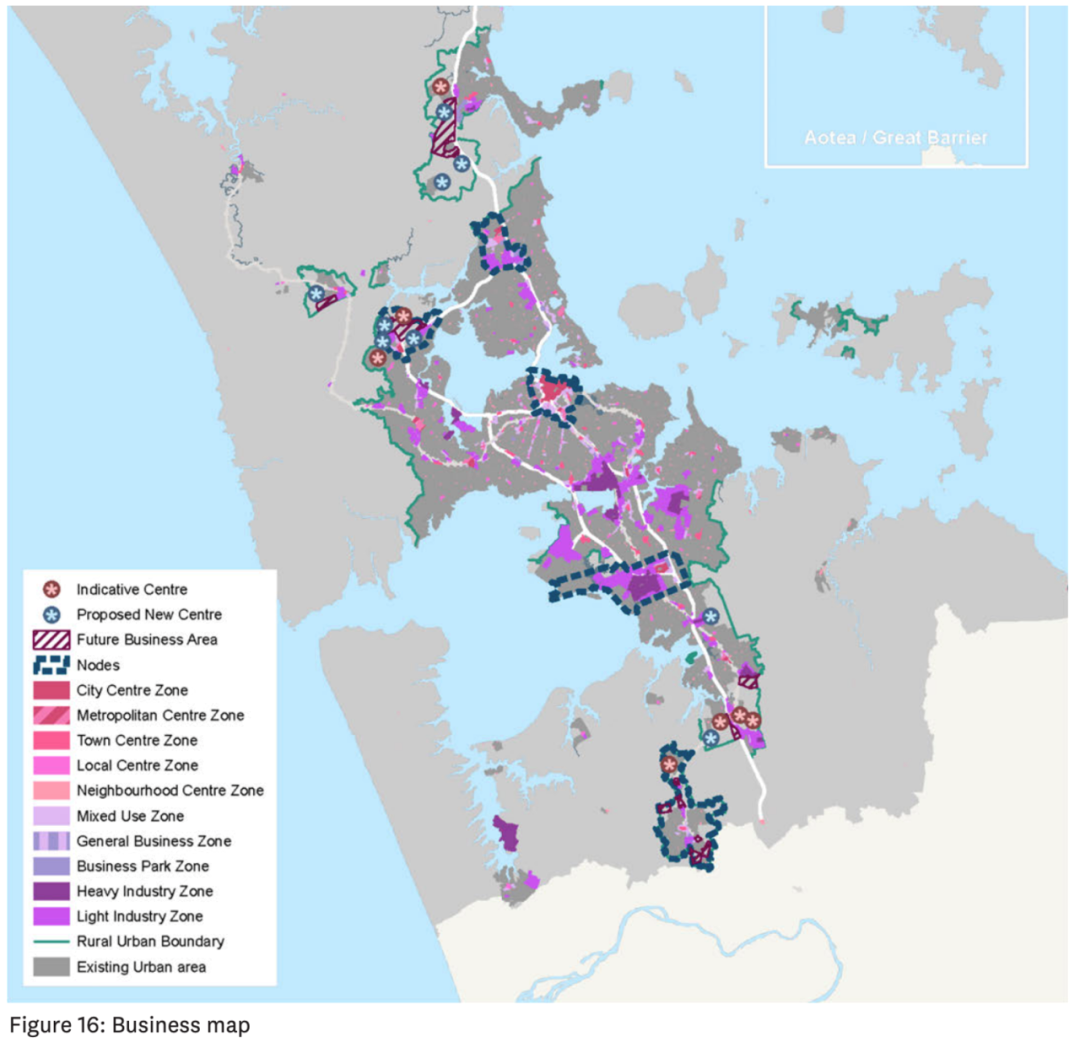
Greenfield land, farms and rural estates outside the second-phase infrastructure planning areas could face a prolonged period without capital gains. This is a blow to major developers that have accumulated large land banks on the outskirts, as very little greenfield land falls within the planned areas.
Residents in these greenfield areas may also complain that their council rates will be spent on nodes they may never use, leading to widespread opposition to the plan among them.
Judging by media coverage and responses across different sectors, the strongest attacks on the FDS have come from major commercial companies. Many of these giants undertake large government infrastructure expansion projects and hold substantial greenfield land banks on the urban fringe. They often know or anticipate the direction of future government infrastructure investment and secure land and other interests before bidding for infrastructure projects.
Redefining the direction of urban infrastructure
For Auckland, cars have largely defined urban development over the past 6 years, or even 30 years. This FDS formally declares the end of that car-based model.
{ad}
Jacques Victor, Auckland Council's general manager of Auckland Plan, Strategy and Research, wants Aucklanders to consider “everything you give up when you spend half your life in a car”. Through the FDS, he hopes to “give more Aucklanders, all Aucklanders, the option to spend less time driving”.
“Providing infrastructure on new greenfield land where there is nothing is very expensive. There is only so much money available. When you invest in providing infrastructure, that means forgoing spending somewhere else. You have to make choices.”
Overall, the shift outlined in the FDS will benefit most existing residents. Increasing density per unit of land has always pushed up urban land prices. Of course, while existing residents enjoy land value gains, they must also contend with a decline in quality of life as population density increases.
The direction of the FDS is not necessarily bad news for future buyers either. Greater urban density will increase housing provision in central areas, bringing a variety of smaller properties into core locations. This will lower the barrier to living in central urban areas and offer more lifestyle choices, although expensive properties will become even more expensive.
Location becomes king again for investment
For today's buyers, the changes taking place in Auckland are ahead of the rest of the country. The FDS gives all property buyers and owners an equal opportunity; after all, land banking is a game for a wealthy few.
This is a new wave of wealth creation. Urban areas are about quality, while suburban areas are about quantity. Auckland is heading towards higher density without looking back. Suburban quantity has had its day, while urban quality is rising from the ground.
In terms of timing, the best opportunity to enter is now, when the policy has just been released but is not yet confirmed. Once expectations of increased land supply fade, differences in location-based land rents will widen, meaning gains in core areas will substantially outstrip those on the outskirts. Holding property in central areas offers greater certainty than banking land on the fringe.
Particular attention should be paid to nodes and areas served by rail, where the story of the ugly duckling becoming a swan will play out again and again.
The current market in key nodes
Recognising these opportunities and understanding the information requires years of local market experience and historical knowledge. Inside information and connections often sit with long-established agents who are deeply embedded locally and know every street.
Tamaki and Māngere
Jane Wang, who covers Tamaki for Auckland's largest local real estate agency, Barfoot & Thompson, has worked in the industry for 21 years. She said:
“At the market peak in 2021, prices for properties on large sections reached extraordinary heights. After two years of correction, prices for these properties have fallen by anywhere from 30% to 50%. We should now be at a low point in prices, offering an excellent opportunity to buy at the bottom.”
Jane believes Tamaki, including Māngere, has well-established railway stations, transport systems and community centres. The draft FDS provides clear expectations for the area's future. Local houses also tend to be old and run-down, making them well suited to redevelopment. These areas have already changed enormously over the past five years: many old houses have been removed in whole groups, replaced by attractive townhouses and terraced townhouses.
“The potential for future appreciation always comes from the land, and land values in Tamaki, including Māngere, are currently particularly significant. If you can obtain bank lending now or release cash from other assets, you should choose properties with development potential.
Owner-occupiers were already buying noticeably faster in May and June. Many new housing projects have been forced to stop because of cash flow problems. Once completed homes have sold, the shortage of supply will become more acute. When the market picks up, developers will return to buy land. Together, these factors will cause prices to rebound rapidly.”
Drury-Ōpaheke area
Cindy Guo, who specialises in lifestyle and rural property in Pukekohe and surrounding areas for Barfoot & Thompson, outlined current conditions in the area.
Franklin, including Drury-Ōpaheke, has many large landholdings, and current market prices have been relatively steady compared with the peak. Buyers are no longer scrambling for land as they did at the height of the market; prices are broadly moving with the overall market. Kiwi Property has purchased around 50 hectares in Drury for a planned commercial centre. The plans also include hospitals, primary schools, shopping centres and other amenities. Two new railway stations are also planned for Drury, making it a transport hub between Auckland and Hamilton.
Cindy believes Drury is conveniently located for people commuting to either Hamilton or Auckland. Without congestion, the drive to Newmarket takes just 20 minutes. As a new area, Drury is developing rapidly. Kiwi Property's planned commercial centre and Stevenson's new industrial park, for example, are bringing more local jobs and many new investment opportunities.